
Whilst we ‘flesh out’ the event we are in two minds over whether we should present a classic ’round trip’ or a point to point route (alternating between the two ports as a start/finish line).
Should you have any suggestions then please CONTACT US with those.
Land Route Choices:
Scenario A: The Round Trip Route (Out-and-Back)
- Concept: Participants start at the Port of Port Elizabeth, travel north along the N2 via the Smelly Creek interchange up to the Coega turn-off (Port of Ngqura gates), turn around, and retrace their steps back down the N2 to finish back at the Port of Port Elizabeth.
- Route Path: Port of Port Elizabeth ➔ N2 North (passing Smelly Creek Interchange) ➔ Coega Turn-off / Port of Ngqura (Turnaround) ➔ N2 South ➔ Port of Port Elizabeth.
- Approximate One-Way Distance: ~23 km to 25 km (depending on the exact port gate positioning).
- Total Event Distance (Round Trip): ~46 km to 50 km.
Operational Profile:
- Pros: Simplifies logistics for a single mass-start and finish line hub (less infrastructure duplication at the finish), allows supporters to congregate easily at a main venue, and provides a predictable, closed-circuit flow for traffic management.
- Cons: Requires a full or major partial highway closure for a longer duration, as the route is active in both directions for a longer period.
Scenario B: Alternating Annual Direction (Up Race one year, Down Race the next)
- Concept: A point-to-point format where one year is an “Up” race (Port of Port Elizabeth to Port of Ngqura) and the alternating year is a “Down” race (Port of Ngqura to Port of Port Elizabeth).
- Route Path (Up Year): Start at the Port of Port Elizabeth ➔ N2 North via Smelly Creek Interchange ➔ Finish at the gates of the Port of Ngqura / Coega SEZ.
- Route Path (Down Year): Start at the gates of the Port of Ngqura / Coega SEZ ➔ N2 South via Smelly Creek Interchange ➔ Finish at the Port of Port Elizabeth.
- Total Event Distance (One-Way per Event): ~23 km to 25 km.
Operational Profile:
- Pros: Mimics classic point-to-point marathons or cycling tours (like the Two Oceans or Comrades concept), highlights both ports equally as grand start/finish destinations on alternate years, and reduces traffic congestion by clearing one side of the N2 corridor faster once the field passes.
- Cons: Requires dual logistical staging areas (start setup and finish setup must be fully built out at both ports independently across alternating years).
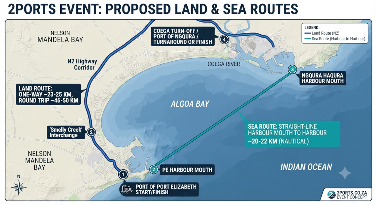
The infographic map above provides a clear visual summary of the two proposed routes for the 2Ports Event within Algoa Bay:
Land Route (N2 Highway Corridor): This route follows the N2 highway from the Port of Port Elizabeth up to the Coega Turn-off near the Port of Ngqura. The map highlights the one-way distance of approximately 23-25 km, which translates to a 46-50 km round trip, and clearly marks key points like the ‘Smelly Creek’ interchange and the start/finish hubs at both ports.
Sea Route (Harbour to Harbour): This route provides a direct, straight-line path across Algoa Bay between the harbour mouths of the Port of Port Elizabeth and the Port of Ngqura. The map specifies this nautical distance as approximately 20-22 km, representing a shorter and more direct connection than the land route.
Sea Route Choices:
The Sea-Going Portion: Straight-Line Harbour Mouth to Harbour Mouth Race
- Concept: A direct coastal or offshore water-craft race (suitable for surfskis, open-water paddling, sailing boats, or power craft depending on event category) traveling across the waters of Algoa Bay in a direct line between the mouth of the Port of Port Elizabeth and the mouth of the Port of Ngqura.
- Route Path: Port of Port Elizabeth Harbour Mouth ➔ Direct open-water course across Algoa Bay ➔ Port of Ngqura Harbour Mouth (and vice versa for a return leg or alternating format).
- Approximate Straight-Line Distance: ~20 km to 22 km (Nautical distance via the shortest open-water line across the bay).
Operational Profile:
Pros:
- Provides a breathtaking, authentic maritime spectacle directly honoring the “2Ports” namesake across Algoa Bay.
- Offers a shorter straight-line distance compared to the highway route, testing navigation and ocean endurance against coastal currents, winds, and swells.
- Can complement the land event or stand alone as a premier aquatic showcase for the region.
Cons:
- Heavily weather- and sea-state dependent (subject to safety calls based on Algoa Bay swells, winds, and National Sea Rescue Institute (NSRI) advisories).
- Requires extensive marine safety coordination, water marshals, and escort vessels across open ocean waters.